The Maps of First Bull Run: An Atlas of the First Bull Run (Manassas) Campaign, including the Battle of Ball's Bluff, June-October 1861КНИГИ » ВОЕННАЯ ИСТОРИЯ
Название: The Maps of First Bull Run: An Atlas of the First Bull Run (Manassas) Campaign, including the Battle of Ball's Bluff, June-October 1861 Автор: Bradley M. Gottfried Издательство: Savas Beatie ISBN: 193271460X Год: 2009 Формат: PDF Страниц: 142 Размер: 64,9 МБ Язык: Английский
The Maps of First Bull Run breaks down the entire operation (and related actions) into numerous map sets or “action-sections” enriched with more than fifty full-color original full-page maps. These cartographic originals bore down to the regimental and battery level and include the march to and from the battlefield and virtually every significant event in between. At least two—and as many as seventeen—maps accompany each “action-section.” Keyed to each piece of cartography is a full facing page of detailed text describing the units, personalities, movements, and combat (including quotes from eyewitnesses) depicted on the accompanying map, all of which make the story of First Bull Run come alive.
A Military Atlas of the First World War Название: A Military Atlas of the First World War Автор: Arthur Banks Издательство: Leo Cooper Год: 2001 Формат: pdf Страниц: 340 Размер: 41.0 Мб...
The Stonewall Brigade Название: The Stonewall Brigade Автор: John Selby Издательство: Osprey Publishing Серия/номер в серии: Men at Arms/30 Год: 1971 Формат: PDF Страниц:...
Atlas of Russian History Автор: M.Gilbert Название: Atlas of Russian History Издательство: New York. OXFORD UNIVERSITY Год: 1993 Страниц: 234 Формат: PDF Язык: Английский...
The Bible Atlas Название: The Bible Atlas Автор: Zaine Ridling Издательство: Access Foundation Год: 2002 Формат: pdf Страниц: 199 Размер: 20 MB Язык: English The...
The Atlas of Civil War Название: The Atlas of Civil War Автор(ы): James M. McPherson Издательство: Running Press Год: 2005 ISBN: 978-0762423569 Страниц: 223 Язык: English...


 Навигация
 Вход на сайт
 Реклама
 The Maps of First Bull Run: An Atlas of the First Bull Run (Manassas) Campaign, including the Battle of Ball's Bluff, June-October 1861
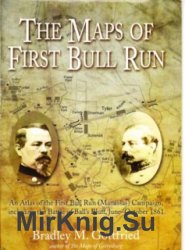


![Small Unit Actions During the German Campaign in Russia [Illustrated Edition]](https://mirknig.su/uploads/posts/2016-06/thumbs/1466667761_003e00dc_medium.jpg "Small Unit Actions During the German Campaign in Russia [Illustrated Edition]")